Winning a modern war is much about sedimentology

Figure 1. The Salt Wash Formation has been interpreted as the preserved deposits from a distributary fluvial system. Some of its sandstone beds bear relatively high uranium concentrations (read more about the fluvial interpretations here: https://pubs.geoscienceworld.org/sepm/jsedres/article-abstract/85/5/544/145482/Quantification-of-a-Distributive-Fluvial-System). Russia has invaded Ukraine. We have been reading and watching in the news how some pieces of high-tech equipment […]
Ganar una guerra moderna tiene mucho que ver con la sedimentología
Figura 1. La Formación Salt Wash ha sido interpretada como los depósitos preservados de un sistema fluvial distributario. Algunas de sus capas de arenisca presentan concentraciones relativamente altas de uranio (lee más sobre las interpretaciones fluviales aquí: https://pubs.geoscienceworld.org/sepm/jsedres/article-abstract/85/5/544/145482/Quantification-of-a-Distributive-Fluvial-System). Rusia ha invadido Ucrania. Hemos estado leyendo y viendo en las noticias cómo algunos equipos y armas […]
Deep-ocean sediments. Part 2: Thermohaline currents that shape the seafloor
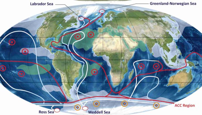
In Part 1, we differentiate between (1) tidal-related currents in shallow marine waters and (2) purely gravitational sedimentary currents. We could add that the former are periodic, as they are controlled by the gravitational fields of the Moon and the Sun on ocean water as the Earth rotates, whereas the latter are ‘spontaneous’ currents driven […]
Sedimentos en las profundidades oceánicas. Parte 2: corrientes termohalinas que dan forma al fondo marino
En la Parte 1 diferenciamos entre (1) corrientes relacionadas con mareas en aguas marinas poco profundas y (2) corrientes sedimentarias puramente gravitacionales. Podríamos agregar que las primeras son periódicas, ya que están controladas por el efecto de los campos gravitacionales de la Luna y el Sol sobre el agua oceánica mientras la Tierra gira, mientras […]
Deep ocean sediments, Part 1: Flows that shape the seafloor.
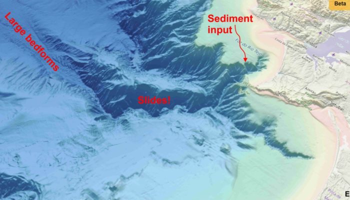
Most of us are aware of the existence of waves and tides. We can see them along our coastlines, and although we may not pay much attention to them, we also know that waves and tides move the sediment resting on the seabed: sand, mud, shells, and… plastics. We can all observe ripples and small […]
Sedimentos en las profundidades del océano, Parte 1: flujos que dan forma al fondo marino.
La mayoría de nosotros conocemos la existencia de las olas y las mareas. Podemos verlas a lo largo de nuestras costas y, aunque no les prestemos mucha atención, también sabemos que las olas y las mareas mueven el sedimento que reposa en el fondo marino: arena, barro, conchas y… plásticos. Todos podemos ver ondulaciones y […]
Psychology in outcrop studies: Heuristic biases: our “best” enemies?

There are not many scientific publications addressing the issue of subjectivity in geological studies and its impact. In one of them, Baddeley et al. (2004) clearly express it in a few phrases: “expert judgments may be biased by their use of heuristics to guide the formation of their opinions” or “the accepted or prior opinions […]
La psicología en los estudios de afloramientos: sesgos heurísticos: ¿nuestros “mejores” enemigos?
No hay muchas publicaciones científicas que aborden el tema de la subjetividad en los estudios geológicos y su impacto. En una de ellas, Baddeley et al. (2004) lo expresan claramente en algunas frases: “los juicios de los expertos pueden estar sesgados por su uso de heurísticas para guiar la formación de sus opiniones” o “las […]
La Popa Ancient Sedimentary Systems (LAPASS)

LAPASS (Ancient Sedimentary Systems of La Popa) is the result of continuous fieldwork since 2017. We have been mapping the La Popa Basin in Nuevo León and Coahuila, Mexico, diligently improving and correcting previous work done by earlier geologists. LAPASS offers professionals a unique opportunity to delve into salt tectonics and its impact on sedimentary […]
Sistemas Sedimentarios Antiguos de La Popa (LAPASS)
LAPASS (Sistemas Sedimentarios Antiguos de La Popa) es el resultado de un trabajo de campo continuo desde 2017. Hemos estado mapeando la Cuenca de La Popa en Nuevo León y Coahuila, México, mejorando y corrigiendo diligentemente trabajos previos realizados por geólogos anteriores. LAPASS ofrece a los profesionales una oportunidad única para profundizar en la tectónica […]